
Publications
- Salliou, Nicolas, Tony Arborino, Joan Iverson Nassauer, Diego Salmeron, Philipp Urech, Derek Vollmer, and Adrienne Grêt-Regamey. “Science-design loop for the design of resilient urban landscapes.” Socio-Environmental Systems Modelling 5 (2023): 18543.
- Salliou, Nicolas, Philipp Urech, João Paulo Leitão, Fabrizia Fappiano, and Adrienne Grêt-Regamey. “Urban water projects must consider landscape architecture.” Nature Water, no. 9 (2025): 967-971.
“Resilient Blue-Green Infrastructures”
2020-2025, Zurich-Singapore-Antananarivo
Futures Cities Laboratory (FCL)
The overall goal of the project is to design and plan functioning blue and green infrastructures, which not only improve urban water efficiency and reduce flooding, but also support local food production, mitigate heat island effects, increase water pollution control, recreation, biodiversity, and ultimately provide jobs for and a higher life quality of citizens. By securing and introducing these nature-based (green) stormwater managements (blue) in the urban fabric, peri-urban areas become more resilient to climate change and population growth. The project is based on an iterative working loop between design, science, engineers and local resource users, civil society actors, and governments using 3D point cloud based physical models, as a common language.
The approach is developed in the vulnerable outskirts of Antananarivo (Madagascar), which is surrounded by large floodplains still providing essential ecosystem services to citizens. The highly dynamic hinterland of this tropical city, which supplies the city with a large share of food, provides a unique environment to understand and analyze the interactions between topography, vegetation, engineering systems and governance as a basis to develop principles for co-developing blue and green infrastructures into existing urban fabrics for application in other tropical cities.
Co-created proposals for resilient urban landscapes were consolidated through the guidance of an inter-disciplinary team of scientists working in Madagascar, Switzerland, and Singapore. This team gave inputs about hydrology, ecology, agronomy, and sociology of Antananarivo. Additionally, the DRS were supported by established collaborations with the French Agricultural Research Centre for International Development (CIRAD), ESSA, and the Ministry of Land Management and Services (MATSF). This co-creative approach also involves local stakeholders from state to municipality levels through repeated iterations that allow for calibrating common goals, requesting data and permits, and discussing possibilities of implementing new ideas.
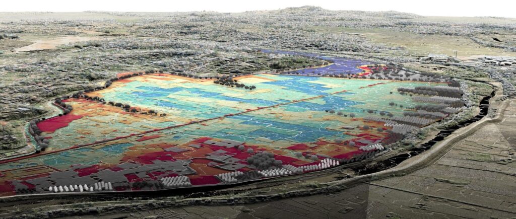
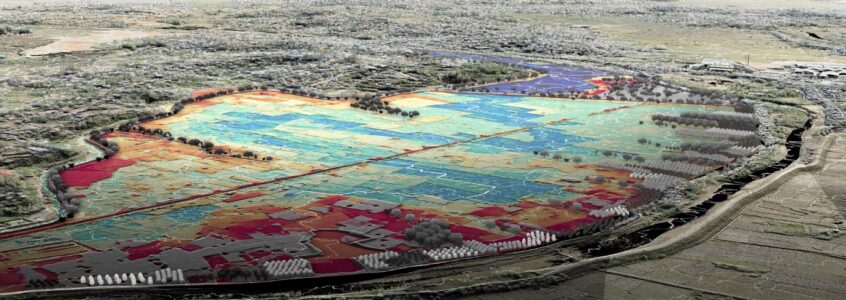
Green and blue infrastructure is developed by ETH students and researchers in the peri-urban area of Antananarivo, Madagascar. The solutions were developed by modifying a LiDAR survey in a highly targeted way and by integrating hydrology through a water flow simulation (flow represented by white lines, and elevation represented from 1248 m in blue to 1250 m AMSL in red).

The project was featured at the main venue of the 19th International Architecture Exhibition of La Biennale di Venezia, curated by Carlo Ratti. The project delivers a new design paradigm that draws its robustness from the vernacular landscape.