


Topology – Spring Semester 2025
Hours: 2 hrs, on Thursdays 12:45-14:30
Room: LVML PC-room HIL H40.8
Lecturers: Matthias Vollmer and Philipp Urech
FUTURING
Each century has extensively shaped city morphology according to technology, mobility and security. Cities of the 21st century are set to be marked by climate change, demographic recession and a shift of global economy. These processes will drive urban transitions, evolving from existing morphology and incrementally changing the perception of familiar places. The urban transitions call for imaginative methods that enhance contextual responsiveness when planning for the coming decades. By 2070, the subtropical climate zone is expected to expand from the south to the north of the Alps, replacing the current temperate climate (Gobiet et al. 2014, Rubel et al. 2017, Beck et al. 2023). This shift will exacerbate urban microclimates, including heat islands, and lead to changes in vegetation. Temperature peaks above 40 degrees, prolonged dry periods, and heavy rainfall will become more frequent. As climate change and biodiversity loss intensify, integrating living systems into human-shaped environments is a key strategy to ensure safe and livable urban areas.
The warming temperatures and altered precipitation patterns will have a significant impact on the vegetation of the Swiss Plateau over the coming decades. Long-established wetland and nutrient-poor grassland plants will decline, while non-native species (neophytes) will become more competitive. Considering new vegetation in shaping urban green spaces plays a crucial role in sustaining the role of plants in mitigating major health risks caused by global warming, pollution, and pandemics. Subtropical vegetation will alter the current perception of Swiss urban landscapes. A subtropicana aesthetic is not merely about a planned introduction of exotic flora but represents a holistic approach to rethinking urban resilience. In parallel to change, including site-specific and preexisting qualities helps to foster culturally significant places and counteract trends of homogenization. This intention aligns with planning and design narratives that incorporate concepts such as pattern language, genius loci, and phenomenological dimensions. Survey-based point cloud and sound modeling methods offer a way to capture and analyze these qualities. Ultimately, the imagination of urban landscapes extends beyond pure data-driven rationalization, incorporating aesthetic, cultural and non-human considerations.
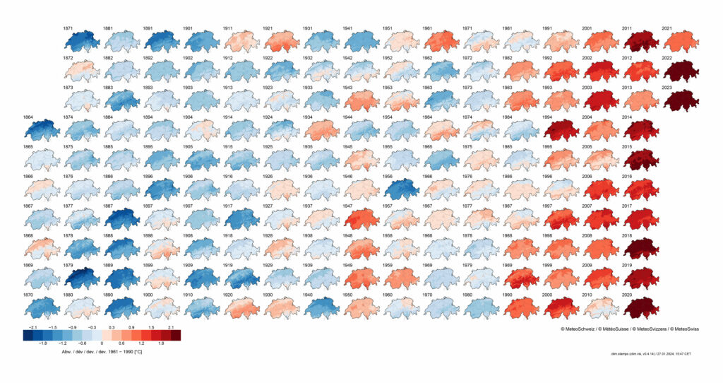
Temperature deviations from the 1951-1990 mean since 1864. Source: Meteo Schweiz
SUPERBLOCK
Urban green spaces can be integrated into cities through various urban design typologies. These include greenways, which follow natural ecological corridors such as rivers; park systems, which connect different neighborhoods, as seen in Singapore’s park connector network; and pedestrian streets, which are incorporated into urban layouts, such as Barcelona’s superblocks. A superblock limits car traffic within a cluster of city blocks, promoting a shift toward pedestrian-friendly and active mobility. This transformation prioritizes walkability, cycling, and social interaction. Within a superblock, streets become low-traffic or entirely car-free, often incorporating playgrounds, gardens, and communal spaces. In Zurich Wiedikon, Sihlfeld is a quarter where most streets remain open to individual motorized traffic. Certain sections could benefit from a superblock layout, creating more pedestrian-friendly open spaces. This course posits the urban transition of Gertrudstrasse from a common neighborhood street into a pedestrian zone featuring subtropical vegetation. The urban strategy mirrors Barcelona’s superblock model, where Gertrudstrasse could serve as a structural axis within a similar framework. To the north, Gertrudstrasse connects to Seebahngraben, offering a potential example for the redesign of other streets in the district.
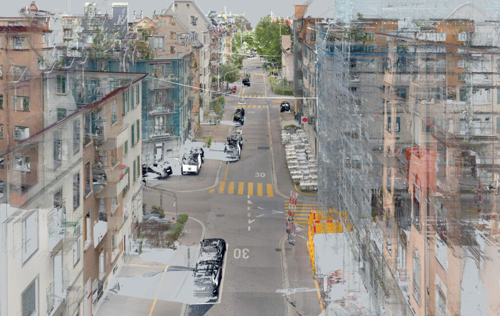
Point cloud model of the Gertrudstrasse. Source: data provided by GeoZ, edited and visualized by LVML.
APPROACH
The aim of this course is to broaden the perception of urban green spaces in Zurich and to reflect on their visual and acoustic potential. In teams of two, you will think about how the Gertrudstrasse could be transformed by integrating qualities you have observed on the daytrip in Ticino. To foster prospective imagination, we will use a method of 3D Collage to juxtapose a “Place of Inspiration” with the “Place of Inquiry”: The Place of inquiry is the Gertrudstrasse, which needs to be reimagined as a pedestrian and communal space. Each group can select a segment along the street to be digitally manipulated. You will choose which parts of the existing context you want to keep or to remove. The Place of inspiration is chosen by your group during the daytrip to Ticino. It has qualities that you wish to digitally transpose to the place of inquiry. You should consider similar dimensions, transferable functions and form. The method of “Collage” allows a fast combination of different landscapes, and to refine it during the course.

During the final presentations at Kino-Bar Xenix, each group explained their ideas about the subtropical aesthetics and presented their audiovisual composition. Guests were Ulrike Wissen, Johanna Just, Julian Raffetseder, Dennis Häusler, Jonas Egeler.