Friesenberg, Zurich
This 3D model represents a geolocated temporal overlay and is featured in the exhibition “Places in Transition” that shows how the city of Zurich changes slowly, unevenly, and often unexpectedly.
This 3D model represents a geolocated temporal overlay and is featured in the exhibition “Places in Transition” that shows how the city of Zurich changes slowly, unevenly, and often unexpectedly.
In this course, we will explore the conditions of a new climate scenario for Zurich, projecting a shift from a temperate to a subtropical climate zone, a transition likely to occur by 2070. Course participants will be asked to investigate this future scenario by juxtaposing existing environments, collecting urban landscape and vegetation samples south of the Alps (Ticino) and transposing them to Zurich.
NewUrbES, part of NRP82 “Biodiversity and Ecosystem Services”, moves beyond conventional sustainability. This design-science research project is developing the tools and knowledge to transform urban environments into biodiverse habitats through regenerative materials, immersive digital design, and transdisciplinary collaboration.
This 3D model represents a geolocated temporal overlay and is featured in the exhibition “Places in Transition” that shows how the city of Zurich changes slowly, unevenly, and often unexpectedly.
In this course, we will explore the conditions of a new climate scenario for Zurich, projecting a shift from a temperate to a subtropical climate zone, a transition likely to occur by 2070. Course participants will be asked to investigate this future scenario by juxtaposing existing environments, collecting urban landscape and vegetation samples south of the Alps (Ticino) and transposing them to Zurich.
Research Project “QUALISCAPES” within the Swiss National Research Programme NRP 81 “Baukultur”. Urban design by Atelier Bonnet (USI).
Topology course “Habitat Infill” in the Fall Semester 2025 led by Philipp Urech and Matthias Vollmer.
The exhibition Places in Transition explores transformations of the urban space of Zürich through a trans-temporal perspective. At the heart of the exhibition are student projects developed at the Large-scale Virtualization and Modeling Lab at ETH Zurich.
QUALISCAPES, part of NRP81 Baukultur, investigates how globalization and standardized development erode the unique character of Swiss cultural landscapes and weaken people’s sense of place. Drawing on design, geography, land system science, social sciences, and cognitive psychology, the project develops participatory strategies to activate placemaking and foster attachment, identity, and stewardship.
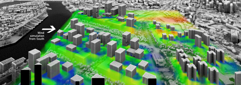
CoCoNet bridges mobility, climate, ecology, and soundscapes to transform urban streets. Through co-creation, spatial modelling, and immersive 3D tools, it integrates nature-based solutions with mobility strategies, fostering dialogue, resilience, and human–nature connections for inclusive, sustainable district-scale change.
In this course, we will explore the conditions of a new climate scenario for Zurich, projecting a shift from a temperate to a subtropical climate zone, a transition likely to occur by 2070. Course participants will be asked to investigate this future scenario by juxtaposing existing environments, collecting urban landscape and vegetation samples south of the Alps (Ticino) and transposing them to Zurich.
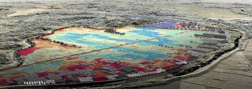
This semester, we will investigate topographic transformations though a historical lens. We will use historical aerial pictures to reconstruct georeferenced 3D terrain models of the past. These historical topographies will be compared to recent surveys to illustrate dynamic conditions within the territorial geometry.
Topology course “Subtropical Blend” led by Matthias Vollmer and Philipp Urech. Authors: Cedric Rytz, Leo Aebli, Matteo Baggenstos, David Bergmann, Gaibul Bhullar, Yuzhe Che, Wen Tsung Chen, Zoe Gyr, Nils Hayoz, Ludwig Henke, Yida Hou, Adrian Kramser, Lara Krieger, Marin Nussbaumer, Timm Rogenmoser, Yuxuan Shi, Mert Ünal, Philippe Wegmann, Colin Wiebking, Hoi Yan Young, Shuyuan Zhang, Mariah Derkach.
Course “Historic Ground” in the lecture series Digital Design Methods III led by Philipp Urech | Authors: Helin Can, Aikaterini Katsarou, Nathan Loretan, Viral Mehta, Aamirah Nakhuda, Isabelle Nguyen, Antonina Nikolic, Yuxuan Shi, Ni-Chin Tsai, Uxía Varela Exposito, Shurui Wang.
Design Studio TUW “Making Greenways” led by Philipp Urech and Susann Ahn. Authors: Alfons Mairhofer, Kathrin Maneval, Julian Sonnleitner, Thomas Buchsteiner, Michael Krammer, Greta Bastian, Alexander Hövel, Stella Morgenstern, Andreas Baumann, Niko Ugljanin, Katrina Herre, Luisa Moser, Isidora Stevanovic, Daniel Kith, Pia Larcher, Lena Peisser.
Topology course “Grassroot Claims” led by Philipp Urech and Matthias Vollmer. Authors: Léo Ornstein, Raffaele Squillacioti, Pin-hsien Tang.
Topology course “Breaking Ground” led by Matthias Vollmer and Philipp Urech. Authors: Elias Böhnlein, Olivier Knecht, Fabio Tehlar, Idoya Ferro Carrión, Ilu Demont, Luana Bearth, Aikaterini Katsarou, Francisco Coch, Jann Märki, Nadia Schib, Rifa Chowdhury, Anna Kotasz, Severin Hitz, Raphael Baumann, Sofie Klaus, Ella Castellani.
This course encompasses data acquisition and modeling to simulation and visualization. The final semester of the Digital Design Methods series focuses on consolidating the techniques previously learned.
Topology course “Mind The Gap” led by Philipp Urech and Matthias Vollmer. Authors: Omar El Sayed, Luca Lepori, Josias Regli, Anna Rothstein, Ellen Stenzel, Aaron Zilinski
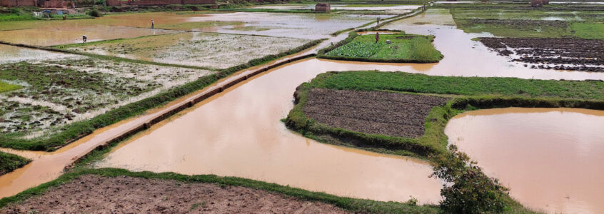
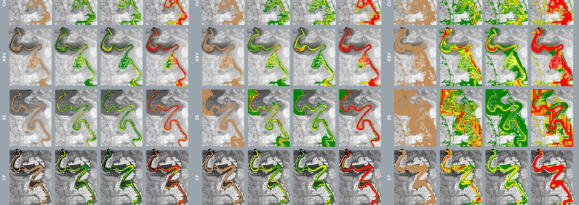
To train workflows for large-scale landscape architectural design, students work on a Remote Investigation Study (RIS) on the topography and floods in the urbanized high plains of Antananarivo, Madagascar. This course covers the most important digital methods in landscape architecture, from data
collection to 2D and 3D modelling, analysis and simulation with various software solutions to visualizations and prototypes.
Design Studio “Madagascar Hand Made” led by Christophe Girot, with Philipp Urech. Authors: Manon Amsler, Matteo Cadei, Catherine Goy, Pascal Hiestand, Laura Klinnert Vlachopoulou, Noemi Koch, Sofia Nava, Samuel Varrin, Alan von Arx Carrascal, Sarah von Steiger, Aline Vonderwahl, Josephine West, Audrey Würges, Qianer Zhu.
Course participants will perform a remote site study on topography and floods in the urbanized high plains of Madagascar. By inspecting point cloud models, designers can understand how a site’s terrain is arranged, in which direction the water flows or where it stagnates, and what the dominant characteristics of the site are.
Publications “Resilient Blue-Green Infrastructures”2020-2025, Zurich-Singapore-AntananarivoFutures Cities Laboratory (FCL) The overall goal of the project is to design and plan functioning blue and green infrastructures, which …
This research project measures and models how tropical urban green spaces—trees, parks, gardens, and rivers—cool cities, reduce floods, and enhance recreation. Findings guide urban design, linking local plant benefits to citywide strategies for mitigating heat and improving livability.
“Landscape Ecology”2010-2015, JakartaFutures Cities Laboratory (FCL) The Ciliwung River has been at the center of human settlements since at least the 4th century A.O. Culturally …